
KFUL has a localizer, but i dont see a ILS IAP and on the bottom of the IAP there is no glide slope angle listed. There is also no VOR nearby to use for the zarow or hamug or qewti or conga intersections. Whats up with that. With the runway being in the middle of a city i would think altitude as important alignment.
Per the name of the approach (LOC/DME), you must have a DME or IFR certified GPS to get distances for each intersection on the approach. That is why there are distances next to each intersection on the map. Maybe I am missing something?
You’ll also have VOR-A approaches to some airports that are in the middle of cities. With these won’t have the vertical guidance, as well, it may not even be lined up with the runway, it could require circle to landing. The feds that design the approaches take the terrain into consideration for altitudes such as MDA etc. In such a populated area, the MDA may be higher than that of the same type of approach at a different airport.
Also consider any remaining NDB approaches, most you’re allowed to descend to a certain altitude prior to the FAF and then to MDA beyond that, and hope that you’re W/I 2 or 3 degrees of the final approach course.
As pilot2009 iterated, the approach in question is a Localizer/DME non-precision approach with no Glide Slope vertical guidance. DME is required to identify the waypoints along the Final Approach Course.
If the Cessna single you are training in is Garmin G1000 equipped, you may be able to use the system’s VNAV guidance which will give you a pseudo glide path to follow.
Exactly…that’s why the '07 and later Cessna’s with G1000 were quite the upgrade!
Not really correct. GPS distance is usually given to the airport center and not the source of the DME equipment.
You may shoot the KFUL LOC approach with a IFR GPS (without DME) because the named intersections are called out on the GPS.
I am editing my original response, as I did a little research on the above.
One can use GPS in lieu of DME…
aopa.org/whatsnew/air_traffi … _lieu.html
I didn’t think so originally, so now the question bears, why have a GPS approach at KFUL with higher minimums if one can do the LOC with GPS as DME???
I think so.
Using your GPS for a DME approach is wrong.
On the KFUL LOC approach using named intersections on the GPS is okay but one may not use the GPS for course guidance inside the FAF. Look at the screen shot below. Each intersection is called out.
http://i43.tinypic.com/abkyvm.jpg
Am I wrong?
Frank Holbert
160knots.com
![]()
You must not have refreshed your page.
You can use your GPS for DME. Localizer would be used for course guidance on the LOC approach
See reference I provided.
The LOC was flight checked to a lower altitude?
The LOC is more accurate than a GPS at this location?
[quote=“lieberma”]
Could this not come down to what equipment you have filed in your flight plan? Obviously if you have GPS you’re filing /G so in addition to having DME. So what happens if you lose your GPS? If you still had DME, you’d still be /A and could shoot the LOC/DME approach. If you didn’t have DME, making you /U, you’re diverting to somewhere else if FUL were below minimums.
Make sense?
BL.
Read the limitations section.
Oddly enough in this case more is less… /G one would most likely be assigned the GPS approach
Operative word is assigned and it would behoove the pilot to request the LOC approach using the ground based LOC for guidance and the GPS overlay for DME for the step down vertical guidance is the way I am reading the AOPA reference.
I personally don’t have DME, so I would have requested the GPS. And KFUL does have a VOR approach that I could consider that has a lower minimum using BWALT fix then the GPS approach.
I would not attempt the LOC without DME with what I have in my plane.
I did.
I don’t see anything that says you cannot use GPS for DME fixes within the FAF to MAP.
I can’t find it now or the approach has changed. I was going to shoot a LOC DME approach with my IFR GPS in IMC a couple of years ago. There was a big step down when you cleared a mountain at about 18 DME, that, the FAF and MAP were all unnamed intersections using DME distance only. The DME did not come from the LOC but instead came from a VORTAC almost 1 1/2 miles from the approach end of the runway.
Later I loaded the approach on the Garmin GPS trainer, Without DME I could not ID the step downs.
Frank Holbert
160knots.com
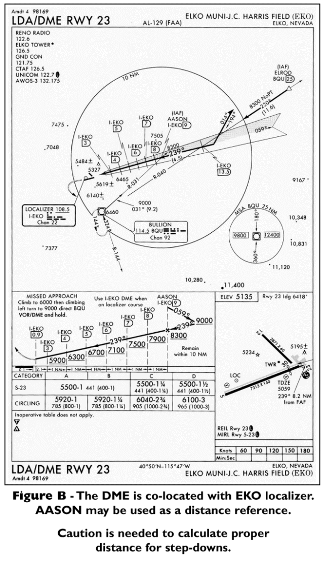
Isn’t what you describe above similar to the figure B in my reference?
aopa.org/images/whatsnew/new … 13figb.gif
While more step downs based on DME from EKO then what you described for your approach, there are no intersecting fixes to validate the DME fix along the localizer.
Use Bullion for DME and you’ll see what I described.
This “figure” approach does take being ahead of the plane, but not that hard of an approach.
Bullion confirms the IAF of AASON as a cross check of 9 miles from EKO
I would have my NAV1 set to EKO of 108.5 with the 239 radial dialed in and NAV two set to BQU of 114.5 with the 031 radial dialed in.
Assuming vectors to final, I would expect track the 239 radial and once NAV 2 centered up on the 031 radial, start my descent based on the DME fixes.
Since I don’t have DME, I would have to rely on my GPS to give me my DME from the EKO VOR which would be perfectly legal from all I read. I would personally put EKO as my waypoint in the GPS to ensure DME accuracy, not sure how others would do this. I would not load the localizer approach.
My course guidance would be strictly based on NAV1 and NOT the GPS.
Assuming full procedure, I would fly on the 031 radial from BQU and execute the procedure turn when my Nav1 centered up on the 239 radial and I flew outbound 13.5 DMA to the intersection 040 radial of BQU (while flying outbound on the 239 radial I would reset Nav 2 to 040 to help cross check where I should start my procedure turn) . After my procedure turn, the DME fixes along the localizer course line would help me make my descent.
In the real world of piloting, I would not do this (way too much work!), but what I describe above would be perfectly legal using the GPS as a replacement for DME from everything I have read. I am not using the GPS for course navigation in my above example.
In the real world of flying I would elect the VOR approach for the lower minimums with what I have in my plane.
Son, I think you lost track of what we were talking about.
Help me then? You said GPS cannot be used for a DME approach. Where am I wrong?
You point out a VOR that requires the use of a DME and a radial?
Altitude is 9000 that steps down to 8300 on the final approach course line at a DME distance from the VOR you bring out.
What am I missing?