I was attempting to track the FAA location identifiers of a NWA flight I was on yesterday. The following location identifiers were listed by Flight Aware:
ZMBRO1 ODI J30 JOT BVT J89 IIU J89 OTK LEESE1.
I’ve been able to use other means to identify the waypoints for my flight except for ZMBRO1, J30, J89, and LEESE1.
Can anyone point me in the right direction to identify/decode these places?
Ahhhh… so you went from Minneapolis to Orlando! Cool - can’t wait to take my daughter there someday.
ZMBRO1 is a Standard Instrument Departure procedure (or SID for short) out of KMSP.
J30 and J89 air high-altitude airways (highways in the sky defined by various navaids or airspace “fixes” [think waypoint for simplicity at this point]).
LEESE1 is a Standard Terminal ARrival procedure (or STAR for short) going into KMCO.
Thanks NeedleNose, cfijames, and pika1000 for the help!!! I actually came from KBIL to KMCO but the KBIL to KMSP leg only had RWF as a location identifier.
This is my first post as a FlightAware member. I stumbled across this site while trying to figure out where the air traffic over my house is going (and it’s been hours of fun so far).
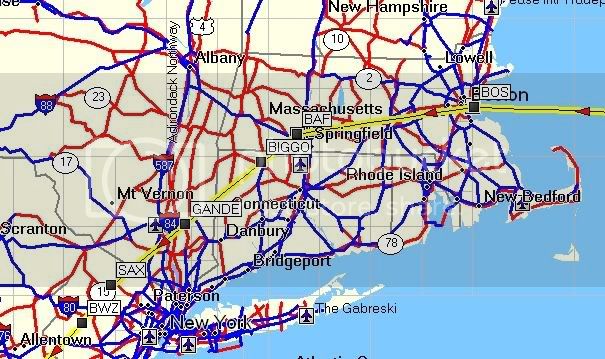
In fact, I think I’ve figured out the route that I live under, but I’m not exactly sure and I was wondering if anyone here can help. I’m located in Northborough, MA – about 35 miles almost due west of Boston.
I’m pretty sure that UAL915 went right over my house earlier. On the “Route” line for that flight it says:
Now I’ve managed to figure out that WHALE is some kind of checkpoint between Cape Cod and Nova Scotia. BOS is obviously Logan Airport. SAX is a VOR station someplace in New Jersey. That leaves J77, which this thread has taught me is a high altitude route.
So here’s my question – is there anyplace online that I can find a map of route J77, or a description of it? I found a chart of the area on AeroPlanner, but it wanted me to buy a premium membership to view it. Is there any website where I can find this information for free?
Almost there, JGeary BOS, in this context, is actually the Boston VOR co-located at BOS the airport.
The “checkpoint” you mention is really called an intersection. They are always named with 5 letters that can be pronounced. There’s a thread somewhere in tis forum (I can’t find it now using the search feature above) that gives some of the more unusual names.
I once found a Web page that shows all of the navaids and fixes that make up the high altitude airways. I tried searching the Net for it so I could provide a link to it, but couldn’t find it to save my life. By chance, I just happened to copy that data into a text file and saved it to my computer!
You can lookup information on the navaids and fixes at AIRNAV.com
A single five-letter pronounceable combination serves as the fix name, assigned identifier and computer code. If a new fix is to be collocated with an existing navigation aid, ILS marker, way point, or other type fix, the original name or name-code applies to both.
It turns out I live on the line (vector?) between BOS and BAF. It looks like that is the same as route J77 on the H12 chart. Pretty cool!
So, on a route description a 5 letter word is an intersection? I’ve heard of that before (sometimes I listen to channel 9 on United… it’s less boring than most of their movies). Flights leaving MHT seem to have BOSOX at the beginning of their route quite a bit, is this an intersection?
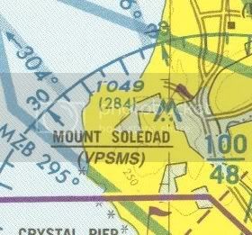
VPSMS is a VFR reporting point found on terminal area charts. They’re also accompanied by pronounceable name - in this case “Mount Soledad”.
So you could file a flight plan with “VPSMS” in the route, and when you get there, you tell the controller you’re at “Mount Soledad”.
Yes and no. You are correct that the VP intersections (and they are listed as intersections under the VP*** name in the GPS database) are VFR reporting points. However, I have received clearances from ATC when flying through a class B airspace under positive ATC control (technically VFR, but really no different from IFR as they give you an assigned heading or navigation fix and altitude) to fly direct to VPSMS or VPLQM (Queen Mary) without ever getting a name. ATC knows that you are a /G (indicates GPS), so they often just use the intersection names. Since some of them are pretty obscure (like the 91/605 freeway interchange in LA aka VPLFX - try finding that as a non-local pilot flying over the zillion LA freeways), I hear them more often called by their identifier.
While all intersections technically have a pronounceable name, many (most?) of them still need to be spelled out by ATC since there is no way to look it up by name. For example, if you were cleared direct to snoopy intersection (which is located directly over Charles Schultz’s house), you wouldn’t know to enter SNUPY in your GPS unless they spelled it for you. Same for ready (REDDE), habzu (HABXU), odds (ODDDS - near Reno), penny (PENNI), etc. etc.